Hiking log & outdoor maps 4.1
Free Version
Publisher Description
You can record your summit successes directly on your smartphone! With the SummitLynx app you can record your mountain tours, bike tours, climbing tours and skiing tours just like in a summit or tour book. The digital hiking maps in the app facilitate orientation in the mountains.
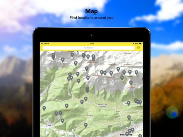
High up on the mountain or along gentle landscapes - record your sportive activities in the app at 400 000 worldwide destinations altogether. If you want, you can share these successes with your friends - directly via the app or via Facebook and Twitter. At the same time, you collect points for hiking badges and take part in competitions and campaigns. Thus, you will be even more motivated to explore nature and reach your goals.
Especially useful: The emergency function mySOS. Enter a contact person who will receive a text message in case you are not back from your hike at the agreed time. Thanks to GPS tracking the mountain rescue service can find you more easily. Ideal for those, who want to increase their safety in the mountains or who are often out and about on their own.
Functions:
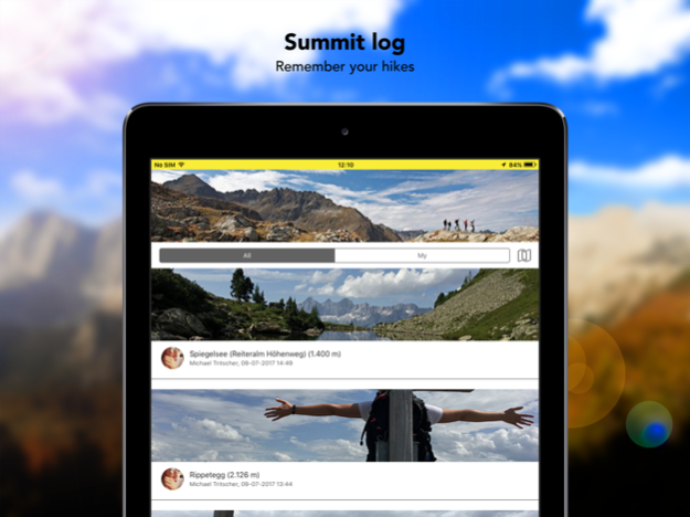
* The smartphone will be your personal summit or tour book
* The digital summit book entries comprise the name of the destination, date & time (by means of automatic GPS localisation). Manually add a picture and a personal note in order to complete your memories just like in a hiking book.
* There are over 400 000 worldwide alpine destinations in the hiking app - summits, mountain cabins, via ferrata, lakes, glaciers, mountain passes and other points of interest. Your smartphone becomes your tour book and your digital stamp pass.
* You can enter different types of movement in your digital tour book: Hikes, bike tours, climbing tours, skiing tours, winter hikes and cross-country skiing tours.
* Collect hiking badges with the digital hiking pass and take part in competitions.
* Emergency communication with mySOS, should something happen to you during the tour.
* Friends list: Share your mountain experiences with your friends.
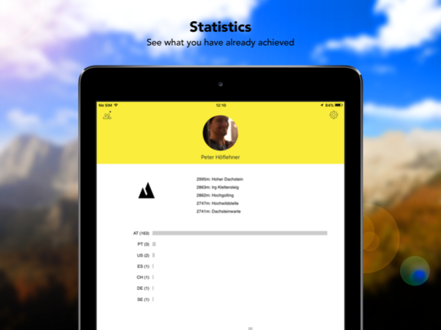
* Get informative statistics about your hiking tours and other mountain experiences.
* Entries are possible without internet connection! Your entries will be temporarily stored until you will be online again.
Functions in our partner regions:
* Approximately 40 partner regions, where you can collect hiking badges and redeem them in the tourist office.
* Tour planning: The most important and popular tours are registered in the app, including length, short description and elevation profile.
In these regions you can collect hiking badges:
* Achensee / Tyrol
* Adlerweg in Tyrol
* Allgäu / Bavaria
* Alpenregion Tegernsee Schliersee / Bavaria
* Bad Kleinkirchheim / Carinthia
* Bad Radkersburg / Styria
* Böhmerwald / Upper Austria
* Ferienregion Imst / Tyrol
* Ferienregion Nationalpark Bayrischer Wald / Bavaria
* Ferienregion Renchtal / Baden-Württemberg
* Gröden / Southern Tyrol
* Hochkönig / Salzburg
* Hochsteiermark / Styria
* Hall-Wattens / Tyrol
* Kaiserwinkl / Tyrol
* Kitzbühel / Tyrol
* Kufsteinerland / Tyrol
* Lamer Winkl / Bavaria
* Lech am Arlberg / Vorarlberg
* Maishofen / Salzburg
* Murau-Murtal / Styria
* Naturpark Almenland / Styria
* Nesselwang / Bavaria
* Olympiaregion Seefeld / Tirol
* Obergraz / Styria
* Obertauern / Salzburg
* Ötztal / Tyrol
* Saalbach-Hinterglemm / Salzburg
* Salzkammergut / Upper Austria, Salzburg & Styria
* Schladming-Dachstein / Styria
* St. Johann in Tirol / Tyrol
* Stubai / Tyrol
* Südsteirische Weinstraße / Styria
* Tiroler Zugspitz Arena / Tyrol
* Top Trails of Germany
* Westerwald / NRW, Hessen, Rhineland-Palatinate
* Wilder Kaiser / Tyrol
* Wildschönau / Tyrol
* Zell am See - Kaprun / Salzburg
* Ötztal / Tyrol
Please find a current list on https://www.summitlynx.com/en/region/
Should you have any questions or suggestions, please contact us at support@summitlynx.com.
Jul 1, 2022
Version 4.1
This version brings some updates to improve the usability of the app and make check-ins even easier.
- New bottom sheet to show nearby locations in the log book
- This sheet also shows more then one location of more locations are nearby
- It also shows the current region if no location is nearby
- New navigation icons
- Push notifications for nearby locations
- New app icon
- As always some improvements and bug fixes
About Hiking log & outdoor maps
Hiking log & outdoor maps is a free app for iOS published in the Recreation list of apps, part of Home & Hobby.
The company that develops Hiking log & outdoor maps is SummitLynx GmbH. The latest version released by its developer is 4.1.
To install Hiking log & outdoor maps on your iOS device, just click the green Continue To App button above to start the installation process. The app is listed on our website since 2022-07-01 and was downloaded 2 times. We have already checked if the download link is safe, however for your own protection we recommend that you scan the downloaded app with your antivirus. Your antivirus may detect the Hiking log & outdoor maps as malware if the download link is broken.
How to install Hiking log & outdoor maps on your iOS device:
- Click on the Continue To App button on our website. This will redirect you to the App Store.
- Once the Hiking log & outdoor maps is shown in the iTunes listing of your iOS device, you can start its download and installation. Tap on the GET button to the right of the app to start downloading it.
- If you are not logged-in the iOS appstore app, you'll be prompted for your your Apple ID and/or password.
- After Hiking log & outdoor maps is downloaded, you'll see an INSTALL button to the right. Tap on it to start the actual installation of the iOS app.
- Once installation is finished you can tap on the OPEN button to start it. Its icon will also be added to your device home screen.
